- Events
- Measured works opens
Measured works opens
Monday 7 December 2015 to Friday 26 February 2016
Free
Come along to a new exhibition on surveyors' views of early Wellington
Surveyors’ views of early European settlement in Wellington
Runs from 7 December – 26 February | 10am – 5pm, Monday – Saturday | Level one
Edward Gibbon Wakefield, the driving force behind the New Zealand Company, made the following exhortation at a meeting of investors in London on 20 March 1839. He was urging the purchase of land before new Crown legislation made it impossible.
Send off your expedition immediately [to New Zealand]... acquire all the land you can... possess yourselves of the soil & you are secure...
The Company created high expectations about the new settlement and handed themselves and surveyors a difficult task. They promised a modern commercial centre and 110, 000 acres of country sections. However, in the rush to start, they still had little detailed knowledge of the topography of the final location and the existing Maori settlements, and set an impossibly short timeframe.
Come along to the Turnbull Gallery and learn stories of the people, troubles, and compromises that gave us the streets of Wellington we know today.
Surveying stories
A taste of what you'll find in the exhibition...
Māori settlements in Te Whanganui a Tara

L-R: Details of Te Wharepouri in 1839, by Charles Heaphy. Ref: PUBL-0011-02-1; Te-Puni in 1839, by Heaphy. Ref: PUBL-0011-02-2; Wi Tako in 1873, by Batt & Richards. Ref: PA2-1576.
In September 1839, when the Tory arrived in Te Whanganui a Tara, Port Nicholson, peoples from Te Āti Awa, Ngāti Ruanui, Ngāti Tama and other iwi from Taranaki were already settled.
Te Wharepouri, Honiana Te-Puni and Wi Tako negotiated with William Wakefield, who was the New Zealand Company’s Principal Agent, and received payment from the New Zealand Company for the Port Nicholson purchase. Before leaving Port Nicholson on 4 October 1839 and sailing to the Marlborough Sounds, Kapiti, Wanganui and Kaipara, William Wakefield left instructions for the survey team on the Cuba to locate the commercial centre on the Lambton Harbour side – the country sections were to be laid out separately.
Instructions for settlement
Meanwhile, the newly appointed Surveyor General for the New Zealand Company, Captain Smith, had been given different instructions by John Ward, Secretary to the New Zealand Company. Thus, when he arrived on the Cuba at Port Nicholson, he chose Pito-one (Petone) as better suited location to establishing a single settlement with an urban centre adjacent to country sections.
New Zealand Land
Company Offices
1 Adam Street Adelphi
1st August 1839
Sir [Captain Mein Smith],
Your first object should be to meet with Col Wakefield... in Cook's Straits... If you find that Col. Wakefield has selected the spot which he considers most eligible for the first and principal settlement, you will proceed thither with the Cuba in order to complete the Survey as soon as possible...
In laying out the Plan of the Town... every holder of a Land Order obtains one full acre of Land within the Town... [I]n framing the Plan of the Town, you should make ample reserves for all public purposes, such as a Cemetery, a Market Place, Wharfage, and probable public buildings, Botanical Garden, a Park and extensive boulevards. It is indeed desirable that the whole outside of the Town, inland, should be separated from the Country sections by a broad belt of land... to be public property, on condition that buildings be [n]ever erected upon it...
I am, Sir, Your very obedient Servant
John Ward
(Extract from letter from John Ward [Secretary to New Zealand Company] to William Mein Smith, 1 August 1839. Ref: MS-papers-11606.)
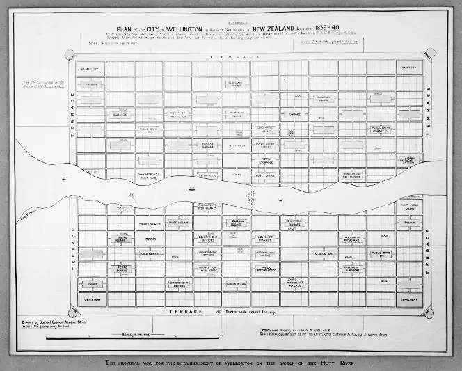
A proposed plan of the city of Wellington in the first settlement in New Zealand, founded 1839-40. Ref: MapColl-832.4796a 1839 15647.
Long talked about as the plan for the principal urban settlement, there is evidence to suggest that Captain William Mein Smith stepped ashore at Petone with only John Ward's written instructions and not Cobham’s plan.
Firstly, the Company directors hadn’t chosen the name 'Wellington' until mid-1840, well after William Mein Smith had left London. Secondly, when the Cuba set sail in August 1839, William Wakefield had only just arrived in the Marlborough Sounds and begun his reconnaissance to select the principal commercial settlement.
Known as the 'Cobham plan', this plan reflected urban planning ideals of the day that had been used in various other new world settlements. Grid-like plans were commonly imposed rather than being in sympathy with the topography. This approach is apparent in the following Mein Smith plan.
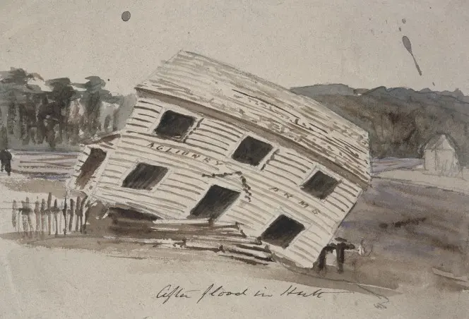
The Aglionby Arms in Lower Hutt after a flood, ca 1842, by Robert Park. Ref: A-032-024.
After the Hutt River flooding in March 1840 brought about relocation of the main European settlement, Wakefield instructed Mein Smith to survey all Lambton Harbour land, including Māori Pa, kianga, and cultivations, and produce a plan for the new settlement.
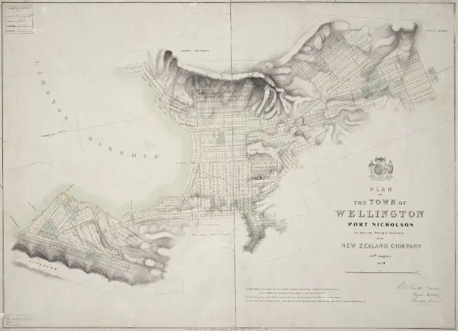
Plan of the town of Wellington, Port Nicholson, by William Mein Smith. Ref: MapColl 832.4799gbbd 1840 317.
The above plan for the layout of Wellington showed was published after the lotteries for selection of the land blocks had been held, around mid-year 1840. The New Zealand Company directors prescribed this system for the layout. It was low cost but inappropriate, and despite Mein Smith's protestations, William Wakefield didn't allow the surveyors to use a better system.
Running the New Zealand Company Survey Office
The achievements of the New Zealand Company survey office were exceptional given the circumstances that they worked in. Over the short space of 10 years between 1840 and 1850, 5 changes were made to the leadership of the Survey Office mainly due to William Wakefield's continual interference in the office's administration and resourcing. They were Captain Mein Smith, from January 1840 to February 1842, Samuel Charles Brees, March 1842 to May 1845, Alfred Wills for 6 months, then David Lewis looked after the daily running of the office, and William Seed looked after the surveying duties.
After William Wakefield died in 1848, William Fox was appointed his replacement. He attempted to revitalise the survey office and appointed Robert Park in late 1849. However, the position only lasted until September 1850 when the Company went into liquidation.

Leaders of the Survey Office. L-R: William Mein Smith; Samuel Charles Brees; Alfred Wills; William Seed; Robert Park.
Roads
Roads were crucial to establishing a commercial centre, connecting it to rural productive land, to other centres and enabling further development of the hinterland. Several early surveyor feedbooks and notebooks record investigations of existing Maori tracks particularly in the western hills of Wellington. In his fieldbook, Robert Stokes surveyed a track that started at the top of The Terrace and traversed the hills over towards Karori.

Survey of Maori Path from Wellington Terrace to Karori, 1843, by Robert Stokes. Archives New Zealand. Ref: R23195399.
The old Porirua Road or North Road was constructed on a route following a Māori path from Johnsonville to Jackson's Ferry (Porirua), then a road was built via Pauatahanui to Paekakariki. As reported by Captain Russell, who oversaw the construction of the road, until this last section was completed
...travellers could reach the northern settlements [from Jackson's Ferry] by swimming their horses across the mouth of the harbour, and proceedings through Pakerua [sic] [bush] to the coast and beyond.

North Road, 1849, by Thomas Henry Fitzgerald. Ref: vMapColl 832.47gmbd (1849) 460 (click to see this map fullsize).
Even after the road was upgraded between 1846 to 1849, travel remained slow going and required overnight stays at public houses on-route.
Topographic representations
The surveyors' cartography was focused on urban planning and subdivision plans. But their eye for depicting topography and vegetation and observation of events in sketches and paintings informs us about the changing geography.
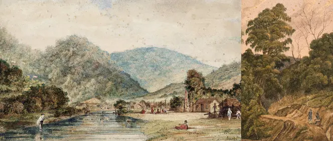
Ngauranga gorge and stream, 1843, by Samuel Charles Brees. Ref: B-031-008; A road through bush; probably the Hutt Valley, 1840-1850, by William Mein Smith. Ref: B-009-013.
In Brees's painting, he depicted Te Āti Awa's Ngauranga pa which was located on the flat land at the mouth of Waitohi stream, just at the entrance to the Ngauranga valley. The monument to Te Wharepouri who died in 1842, can clearly be seen. Brees wrote:
the natives of his Pa erected a monument to his memory at Nga Houranga... A large canoe having been sawed into three pieces transversely, the middle part was set up on six posts, and the two extremites placed together and raised up on their ends, a bunch of feathers being placed on the top.
Mein Smith's painting showed a road at an early stage of construction and the dense podocarp forest that stood around the Wellington area. The tracks which eventually formed the North Road became roads over several stages. Tracks were cut as bridal paths improving levels and lines as required for the final road. Beaches were used where practicable to reduce costs. Once a section of path was cut, it was widened, then metalled to enable heavier traffic.
Māori settlements, then alienation of land
Seeking trade opportunities and a safe haven from conflicts, Te Āti Awa, Ngāti Ruanui, Ngāti Tama and other iwi from Taranaki established ahi kā around Te Whanganui-a-Tara through a series of migrations, the last known as Tama-te-uaua. Pā and cultivations around the harbour were located on the shoreline, next to rivers and flat land, and on prominent land.
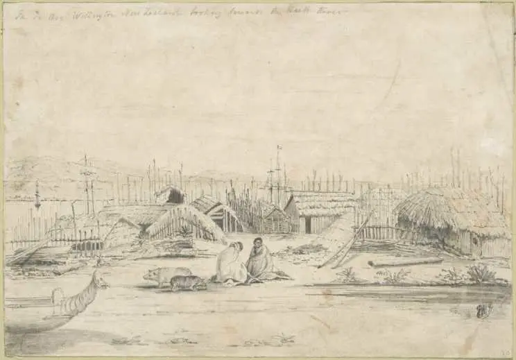
Edmund Norman, Pa, Te Aro, Wellington looking towards the Hutt River, ca 1842. Ref: A-049-001.
For instance, people of Ngāti Ruanui and Te Āti Awa lived at Te Aro pā when Wakefield and the New Zealand Company settlers arrived. At that stage the pā was extensive and probably well-populated. The southern end was located at present-day Te Aro Park on the intersection of Taranaki and Manners Streets, and the northern end on the corner of Taranaki and Wakefield Streets. Even after 10 years of European settlement, the pā had 36 huts and a population of 186, according to an 1850 survey by Native Secretary H. Tracey Kemp.
It was an ideal location on the shoreline, somewhat protected from southerlies, and next to a swamp and flat arable land.
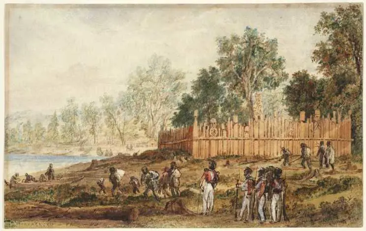
Samuel Charles Brees, Makaenuku Pa; natives preparing to leave the Hutt, ca 1845. Ref: A-179-013.
Despite some guarantees that Maori could retain some pā and cultivations, the New Zealand Company, and later local and central governments, used various strategies to alienate Maori from their lands. By 1890s and 1900s, few Maori lived around Te Whanganui-a-Tara.
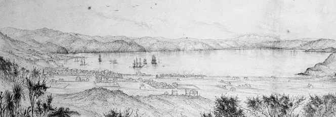
Wellington, Port Nicholson, 1851, by Edmund Norman. Ref: B-009-007.
Edmund Norman's 1851 view of Wellington shown at the cusp of change. Still large gaps or unoccupied sections are visible in central township due to absentee owners and the large Te Aro Swamp which could not be built on until land in the area was partially drained by the 1855 earthquake. In the same year as Norman's sketch, a proposal for the first harbour reclamation was commissioned. The Port Nicholson natural waterfront was about to change to an industrial commercial centre.
Further reading
A.G. Bagnall et al. S.C. Brees: artist and surveyor. Alexander Turnbull Library Occasional publications, no. 2.
A. Ballara. "Te Whanganui-a-Tara: phases of Maori Occupation of Wellington Harbour c. 1800-1840." D. Hamer and R. Nicholls eds. The making of Wellington 1800-1914. Wellington: Victoria University Press, 1990, pp. 9-34.
P. Burns. Fatal success: a history of the New Zealand Company. Auckland: Heinemann Reed, 1989.
Dictionary of New Zealand biography, vol. 1., 1769-1869. Wellington: Allen & Unwin and Dept. Internal Affairs, 1990.
D. Hamer. "Wellington on the urban frontier." D. Hamer and R. Nicholls eds. The making of Wellington 1800-1914. Wellington: Victoria University Press, 1990, pp. 227-254.
B. Maysmor. North road: revisiting the map of the road from Johnsonville to Paekakariki drawn by Thomas Henry Fitzgerald in 1849. Wellington: Pataka Museum, 2008.
R. Montgomery. "Absolutely positively not the first plan for Wellington: unravelling popular misconceptions about the process of planning New Zealand’s capital city." Australasian planning history conference held in Wellington, 5-7 Feb 2014.
B. Patterson. "‘A queer cantankerous lot...’: the human factor in the conduct of the New Zealand Company’s Wellington surveys." D. Hamer and R. Nicholls eds. The making of Wellington 1800-1914. Wellington: Victoria University Press, 1990, pp. 61-88.
L.E. Ward. Early Wellington. Wellington: Whitcombe & Tombs, [1928].
Feature image: Detail of William Mein Smith, The harbour of Port Nicholson and the town of Wellington, 1842. Ref: G-653.