Coates, Thomas, 1847?-1927
Arrived in 1866 aboard the 'Winterthur' with brother Edward Coates (1843-1905). Bought land in the Kaipara Harbour in the 1870s with his brother (Unuwhau and Ruawai blocks). Uncle of Joseph Gordon Coates, Prime Minister 1925-1928. Married Elizabeth Phillips (1846-1926) in 1873 and moved to Kaiwaka in 1886.
Thomas and Elizabeth Coates built a house known as 'Sudeley House' on the summit of Hobson Point hill above Orakei Bay. They went to Orakei in 1893 as the first European residents of Orakei leasing a large block of native land. The house was named for the childhood home of Elizabeth in Winchcombe, Gloucestershire, England.
Image
Date:
ca 1900-1945
By:
Associated Photographic Service Inc; Bartlett, Robert Henry, 1842-1911; Collingridge, Alexander, -1942; Collins, Tudor Washington, 1898-1970; Raine, William Hall, 1892-1955; S P Andrew Ltd; Schmidt Studios; Stewart and White Ltd; W H Bartlett (Firm)
Reference:
PAColl-0508
Description:
Photographs of the Coates family, including ones of what are probably Gordon Coates' parents, brother and sisters, and children, and others of Coates in his professional and personal life. The collection includes a photograph of the interior of the Canadian parliament buildings in Ottawa and one of a visit by Prime Minister Peter Fraser to the NZEF in Egypt.
Quantity: 41 b&w original photographic print(s).
Map
Date:
1873 - 1925
Reference:
MapColl-832.11gbbd/1873- (1971)/Acc.35845
Description:
Map of Kaipara Harbour from Ruawai, Tokatoka and east to the Otematea County boundary and State Highway 1, Hakaru, south to Topuni and Port Albert.
Shows original purchases of Edward and Thomas Coates, subsequent purchases and sales and owners, Maori settlements and pa pites, a 3,300 acre pine forest, state highways, railways, historical battle sites, churches, missions, and pioneer historical information. Rivers, creeks and forests are also identified.
Traced over New Zealand Cadastral maps one inch to one mile. NZMS Ruawai Sheet N27 survey office records and Maungaturoto Sheet N28.
Quantity: 1 manuscript map(s).
Physical Description: Felt tip pen on paper, part coloured, scale indeterminable, 43 x 80.5 cm.
Transfers: From Manuscripts & Archives - Sutch, William Ball, 1907-1975. Papers (Exact reference unknown).

Map
Date:
1875 - 1972
Reference:
MapColl-832.11gbbd/1867-1973 (1975)/Acc.35848
Description:
Four maps of the Coates brothers' land between the Kaipara Harbour and the Arapaoa River, from Ruawai and east to Pahi, over different timeframes.
First map; 'Original holdings - c. 1875'. Shows the Coates brothers' land blocks; the Unuwhao (2500 acres), the Hukatere block (10,410 acres leased from Maori owners) and the Ruawai; also shows Ruatuna House, Thomas Coates' House 'Te Kawau', the horse trek from Tinopai at Komiti Bay to Paparoa. Land ownership notes on map quote sources.
Second map; 'The Three Estates - landholding at greatest extent c.1921'. Shows the three Coates estates Ruawai, The Swamp and Unuwhao, as well as small area owned by the Education Department. Land ownership notes on the map quote sources. As per Cadastral Maungaturoto Sheet 7128.
Third map; 'Private sales, crown sales for soldier settlement by 1948'. Map shows land transferance and sales to returned soldiers via the Crown. Reference notes beside map.
Fourth map: 'The Remnant - 1972'. Shows remaining Ruatuna property, Coates Memorial CHurch, State Highway No. 12, Post Office Matakohe, what was the horse track to Tinopai in 1875 as tar sealed road. D.R. Coates had sold farm.
Areas and survey plans taken from New Zealand Cadastral maps one inch to one mile. NZMS Ruawai Sheet NZ7 survey office records 1.10.1963 and Maungaturoto Sheet NZ8 survey office records 1.2.1964.
Signed A.P.B.W. Aug 1975
Quantity: 4 manuscript map(s) on one sheet.
Physical Description: Felt tip pen on paper, part coloured, scale indeterminable, 56 x 76 cm.
Transfers: From Manuscripts & Archives - Sutch, William Ball, 1907-1975. Papers (Exact reference unknown).
Online
Image
Date:
[ca 1910]
From:
Price, William Archer, 1866-1948 :Collection of post card negatives
Reference:
1/2-000773-G
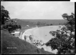
Description:
View of Orakei Bay (now known as Okahu Bay) looking west. In the immediate foreground are sewer pipes and the newly constructed sewer running along the beachfront at what is now Tamaki Drive.
A lone house, 'Sudeley House' belonging to Thomas and Elizabeth Coates, can be seen in the distance on the summit of Hobson Point hill.
Taken by William A Price ca 1910.
The lone house on the Hobson Point hill belonged to settler Thomas Coates, see 'Opening up Orakei', New Zealand Herald, 5 September 1929.
Other Titles - View of Oraki Bay, Auckland
Inscriptions: Photographer's title on negative - bottom left - Orakei Bay. No 1795D
William Archer Price lived and practised in Queen Street, Northcote, 1909-1910. Source: New Zealand Post Office directories
Quantity: 1 b&w original negative(s).
Physical Description: Dry plate glass negative 4.5 x 6.5 inches
Processing information: The house on the summit of Hobson Point above Orakei Bay had been incorrectly identified as a named home 'Conspio House'. Record updated on 29 August 2017.
Online
Image
Date:
[ca 1910]
From:
Price, William Archer, 1866-1948 :Collection of post card negatives
Reference:
1/2-001263-G
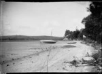
Description:
View of a yacht lying on its side near the high water mark on the tidal flats in Oraki [ie Orakei] Bay (part of Hobsons Bay). A two storey house 'Sudeley House' (belonging to Thomas and Elizabeth Coates) can be seen on the summit of Hobson Point hill on the opposite side of the bay.
Taken by William A Price in early 1900s.
The lone house on the Hobson Point hill belonged to settler Thomas Coates, see 'Opening up Orakei', New Zealand Herald, 5 September 1929.
Other Titles - View of Oraki Bay, Auckland
Inscriptions: Photographer's title on negative - bottom right - Oraki Bay. Remuera. 1008.
Relationship complexity - A similar view, taken from the other side of the yacht, is available at 1/2-001039
William Archer Price lived and practised in Queen Street, Northcote, 1909-1910. Source: New Zealand Post Office directories
Quantity: 1 b&w original negative(s).
Physical Description: Dry plate glass negative 4.5 x 6.5 inches
Processing information: The house on the summit of Hobson Point above Orakei Bay had been incorrectly identified as a named home 'Conspio House'. Record updated on 29 August 2017.
Online
Image
Date:
[ca 1910]
From:
Price, William Archer, 1866-1948 :Collection of post card negatives
Reference:
1/2-000775-G
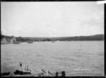
Description:
View of Orakei Bay (now known as Okahu Bay) looking south. In the immediate foreground is Orakei wharf. The newly-laid sewer pipe can be seen running along the beachfront at what is now Tamaki Drive.
A house called Sudeley House belonging to Thomas Coates can be seen in the distance on the summit of Hobson Point to the right of frame.
Taken by William A Price ca 1910.
Information about the house belonging to Thomas Coates can be found in the article 'Opening up Orakei', New Zealand Herald, 5 September 1929.
Other Titles - View of Okahu Bay, Auckland
Inscriptions: Photographer's title on negative - bottom right - Orakei Bay. No 1797D
William Archer Price lived and practised in Queen Street, Northcote, 1909-1910. Source: New Zealand Post Office directories.
Quantity: 1 b&w original negative(s).
Physical Description: Dry plate glass negative 4.5 x 6.5 inches
Processing information: The record was updated on 25 August 2017 to correct the information about the house seen on the Hobson Point summit. The house had been incorrectly identified as 'Conspio House' from an inscription on a British map reproduced in "Auckland by the sea; 100 years of work and play" by David Johnson, 1988 (p 127).
Share
